BEST IMAGE QUALITY
We provide numerous configurations of RGB cameras with a resolution up to 42 Mpix as well as a precise ULS LiDAR laser scanning system. MicaSense multispectral cameras complement the offer, including the Altum model with an integrated thermal sensor.
DOUBLE DATA REGISTRATION OPTION
Thanks to the high payload weight capacity, a combination of a high resolution RGB camera and a multispectral camera (MicaSense) is available. This gives you completely new opportunities that lead to time and money savings.
AVAILABLE CONFIGURATIONS OF PHOTOGRAMETRIC SYSTEMS AS TRINITY F90+'S PAYLOADS (PRICE INCLUDES CAMERA/ULS, PAYLOAD, CONNECTIONS, INTEGRATION)
- up to 3 echos
- 240 000 points/sec.
- FOV: 70 °
- POS solution: APX-15 UAV
- laser scanner: LIVOX Avia
- precision: 1.8 – 2.5 cm, accuracy: <3.0 cm
Ask about the price
- Simultaneous images collection: 5 spectral bands RGB NIR RedEdge (MicaSense) and high resolution RGB images (Sony)
- 6.94 cm/pix @100 m AGL (MicaSense)
- resolution of 20.1 Mpix (Sony)
- 2.66cm RGB/pix @ 100 m AGL (Sony)
- multispectral data for vegatation analysis (MicaSense) + high resolution orthophotomaps, 3D models and DSM (Sony)
price 8.290,00 EUR *
- 5 spectral bands
- 6.94 cm/px @100 m AGL
- multispectral data for vegatation analysis
- 1 flight => orthophotomap (5 bands) & DSM & point cloud
- various vegetation indexes for plants’ stress and health analysis
- thermal data for water management analysis, animal detection, mapping of water pools and frosts
price 11.450,00 EUR *
- Simultaneous images collection: 10 spectral bands (Coastal blue 444 nm, blue 475nm, Green1 531 nm, Green2 560 nm, Red1 650 nm Red2 668 nm, RedEdge1 705 nm, RedEdge2 717 nm, RedEdge3 740 nm, NIR 842 nm)
- 6.9 cm/pix @100 m AGL
- multispectral data for vegatation analysis + direct comparison of the data with the Landsat and Sentinel satellite imagery
- various vegetation indexes for plants’ stress and health analysis
price 12.040,00 EUR *
Sony UMC + TX Thermal
Coming soon!
* Proces excluding VAT
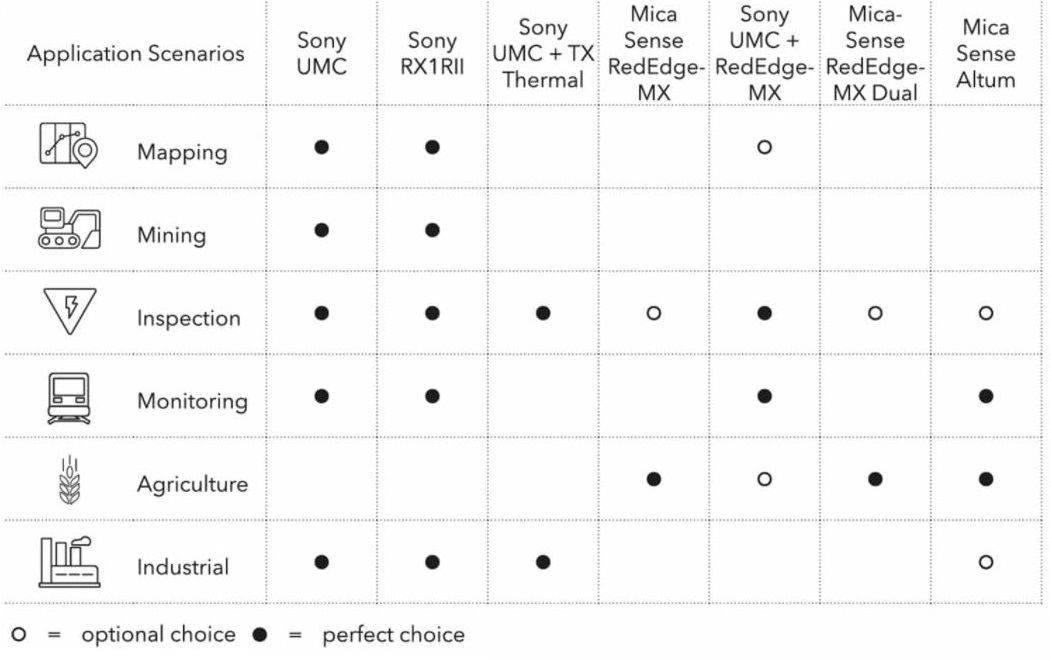
Sensors and their application